Panama touts success in recovering rainforest territory.
- By : James Bryson
- Category : Agriculture, Conservation, Environmental

https://www.laestrella.com.pa/nacional/220422/panama-recupera-decada-3-cobertura-boscosa
From 2012 to 2021, Panama managed to recover 3% of forest cover, going from 65% to 68% of the total, confirmed the Minister of the Environment, Milciades Concepción.
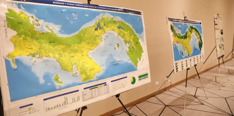
The results are part of the findings recorded in the first Map of Forest and Other Wooded Land 2021, which was presented this Friday, as part of the commemorations of World Earth Day.
“In 2012 we had 65% of the forest cover, today we have 68%. Despite the environmental problems, Panamanians have begun to become aware (with the environment), but there is still a lot to do,” he said. Conception.

The cartographic material was generated after the analysis of the 33 categories of the Forest Coverage and Land Use 2021 map, which totaled 68% of the forests, explained the Ministry of the Environment (Miambiente).
It shows at the level of provinces and districts the balances of forests and other lands in the country and in turn identifies the variables that directly influence changes in forest cover.
According to MiAmbinete, each result was elaborated with remote sensing methodologies using satellite images from the Sentinel-2 MSI sensor, with a spatial resolution of 10m, the sensor has 13 spectral bands, of which the bands used were: B8 (Red ), B3 (Green) and B4 (Blue), these bands allowed a clear identification of areas of forest, water and other land.
With the presentation of the first Map of Forests and Other Wooded Lands 2021, MiAmbiente assumes the challenge of implementing the National Monitoring System for Multipurpose Forests, and makes the decision to create the Department of Remote Sensing to provide permanent information on the state of forests by through a territorial monitoring system, which will make it possible to show the situation of the forests and their trends through the coverage of forest and other wooded land at the national level.

The map presents the following categories with their definitions:
- Forests: Lands that extend for more than 0.5 hectares, endowed with trees with an average height greater than five meters, a canopy cover greater than 30% or trees capable of reaching these thresholds in situ, as long as it is land that have been declared for restoration, conservation or forest management purposes. In the latter case, when it comes to areas where abiotic conditions limit the trees to reach five meters in situ, it will be enough to exceed 30% coverage. It does not include land subject to a predetermined agricultural or urban use.
- Other wooded land: Land that extends over 0.5 hectares, endowed with trees with an average height of five meters and a canopy of 30%.
- Other Wooded Land: All land that has not been classified as “forest” or “other wooded land”
- Continental waters: It refers to the waters that are observed in the following water formations: Rivers, lakes, lagoons and reservoirs. The incorporation of the characteristics of the vegetation of five meters (average height) and a canopy of 30%, is due to the need to include the vegetation in its successional state, with the aim of giving relevance to this important initial stage of our forests.


No Comments